


boyard ville

Maca8284
User
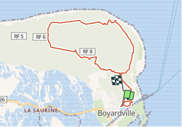

Length
10.5 km

Max alt
20 m

Uphill gradient
65 m
Km-Effort
11.3 km

Min alt
0 m

Downhill gradient
60 m
Boucle
No
Creation date :
2019-08-21 09:43:01.136
Updated on :
2019-08-21 13:49:57.943
2h35
Difficulty : Very easy

FREE GPS app for hiking
 SityTrail
IGN / Geographical institutes
SityTrail Plus
The world is yours!
About
Trail Walking of 10.5 km to be discovered at New Aquitaine, Charente-Maritime, Saint-Georges-d'Oléron. This trail is proposed by Maca8284.
Photos


Positioning
Country:
France
Region :
New Aquitaine
Department/Province :
Charente-Maritime
Municipality :
Saint-Georges-d'Oléron
Location:
Unknown
Start:(Dec)
Start:(UTM)
636281 ; 5091984 (30T) N.
Comments