


katzenthal le galtz

pascalloos
User
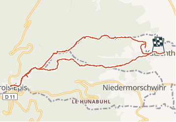

Length
10.8 km

Max alt
720 m

Uphill gradient
494 m
Km-Effort
17.5 km

Min alt
263 m

Downhill gradient
505 m
Boucle
No
Creation date :
2019-08-21 12:07:52.202
Updated on :
2019-08-21 18:20:22.96
6h00
Difficulty : Very easy

FREE GPS app for hiking
 SityTrail
IGN / Geographical institutes
SityTrail Plus
The world is yours!
About
Trail Walking of 10.8 km to be discovered at Grand Est, Haut-Rhin, Katzenthal. This trail is proposed by pascalloos.
Photos


Positioning
Country:
France
Region :
Grand Est
Department/Province :
Haut-Rhin
Municipality :
Katzenthal
Location:
Unknown
Start:(Dec)
Start:(UTM)
372018 ; 5329740 (32U) N.
Comments