


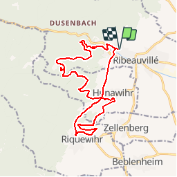
De Ribeauvillé à Riquewihr

JMCMoreau
User

Length
16.9 km

Max alt
599 m

Uphill gradient
601 m
Km-Effort
25 km

Min alt
251 m

Downhill gradient
601 m
Boucle
Yes
Creation date :
2019-08-22 09:41:10.744
Updated on :
2019-08-22 09:50:03.928
5h30
Difficulty : Medium

FREE GPS app for hiking
 SityTrail
IGN / Geographical institutes
SityTrail Plus
The world is yours!
About
Trail Walking of 16.9 km to be discovered at Grand Est, Haut-Rhin, Ribeauvillé. This trail is proposed by JMCMoreau.
Description
Boucle parmi les vignobles, les villages, la montagne et les bois.
Positioning
Country:
France
Region :
Grand Est
Department/Province :
Haut-Rhin
Municipality :
Ribeauvillé
Location:
Unknown
Start:(Dec)
Start:(UTM)
374908 ; 5339443 (32U) N.
Comments