Trail Walking District of North Vancouver - Wikiloc - Mount Seymour Trail - Photo
 Alizée.pee
Alizée.pee

User GUIDE

© OpenStreetMap contributors
Length
Length
8 km
Max alt
Max alt
1445 m
Uphill gradient
Uphill gradient
536 m
Km-Effort
Km-Effort  
15.1 km
Min alt
Min alt
1022 m
Downhill gradient
Downhill gradient
535 m
Boucle
Boucle
Yes
Creation date :
2019-08-26 12:30:11.847
Updated on :
2019-08-26 12:36:22.008

(0 Reviews)

Walking
Walking
3h01
Difficulty : Difficult

Scan this QR Code to open this trail in the SityTrail application

FREE GPS app for hiking

Logo SityTrail SityTrail

IGN / Geographical institutes

Download SityTrail from the App Store Download SityTrail from Google Play

Logo SityTrail SityTrail World

The world is yours!

Download SityTrail from the App Store Download SityTrail from Google Play Download SityTrail on Huawei AppGallery

About

Trail Walking of 8 km to be discovered at British Columbia, Unknown, District of North Vancouver. This trail is proposed by Alizée.pee.

Description

Cette randonnée traverse 3 pics avant d'arriver sur le sommet du Mont Seymour, qui offre une vue panoramique magnifique. Ce n'est pas trop touristique, ce qui est assez agréable.

Néanmoins, il faut faire attention lors des passages des pics car il se peut qu'il y ait de la neige ou de la glace. Il faudra dès lors un équipement adapté.

Elevation profile

Positioning

Country:
Canada
Region :
British Columbia
Department/Province :
Unknown
Municipality :
District of North Vancouver
Location:
Unknown
Start:(UTM)
503705 ; 5468313 (10U) N.

Trails nearby

Trail Walking Coquitlam - Wikiloc - Coquitlam, BC, Minnekhada Regional Park - Photo
Walking
GUIDE
Alizée.pee

Walking

Medium
Coquitlam, British Columbia, Unknown, Canada
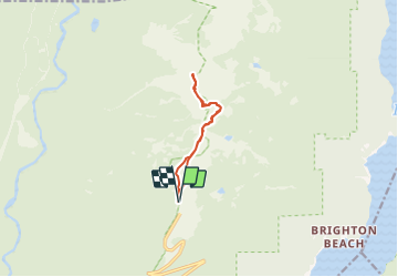
7.4 km | 11 km-effort
2h 17min
Yes
Trail Walking Anmore - Wikiloc - Buntzen Lake, Port Moody, BC - hike around lake - Photo
Walking
GUIDE
Alizée.pee

Walking

Difficult
Anmore, British Columbia, Unknown, Canada
9.7 km | 13.5 km-effort
2h 51min
No


Close
My subscriptions