


Marche TL 09/19 Col du Boenlesgrab - FA Buchwald

patrickbeyrath
User
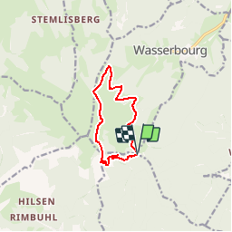

Length
9.4 km

Max alt
1154 m

Uphill gradient
407 m
Km-Effort
14.8 km

Min alt
834 m

Downhill gradient
401 m
Boucle
Yes
Creation date :
2019-08-30 05:09:32.163
Updated on :
2019-09-10 05:47:07.697
--
Difficulty : Medium

FREE GPS app for hiking
 SityTrail
IGN / Geographical institutes
SityTrail Plus
The world is yours!
About
Trail Walking of 9.4 km to be discovered at Grand Est, Haut-Rhin, Wasserbourg. This trail is proposed by patrickbeyrath.
Description
Col du Boenlesgrab - Kaltenbrunnen - Drei Schoepf - Wasenmatten - Buchwald - Strohberg - Schellimatt et retour
Positioning
Country:
France
Region :
Grand Est
Department/Province :
Haut-Rhin
Municipality :
Wasserbourg
Location:
Unknown
Start:(Dec)
Start:(UTM)
361786 ; 5315349 (32T) N.
Comments