


PR- Lac B&N-6Km

JMCMoreau
User
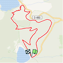

Length
5.5 km

Max alt
1243 m

Uphill gradient
313 m
Km-Effort
9.7 km

Min alt
952 m

Downhill gradient
312 m
Boucle
Yes
Creation date :
2019-08-26 16:12:34.717
Updated on :
2019-08-30 06:54:40.333
3h00
Difficulty : Medium

FREE GPS app for hiking
 SityTrail
IGN / Geographical institutes
SityTrail Plus
The world is yours!
About
Trail Walking of 5.5 km to be discovered at Grand Est, Haut-Rhin, Orbey. This trail is proposed by JMCMoreau.
Description
Tracé dans le sens dénivelé positif faible pour le groupe PR
Positioning
Country:
France
Region :
Grand Est
Department/Province :
Haut-Rhin
Municipality :
Orbey
Location:
Unknown
Start:(Dec)
Start:(UTM)
358573 ; 5330567 (32U) N.
Comments
Belle rando mais descente difficile A faire peut-être dans l.autre sens