


bedous G4 heyt

LouisROGER
User GUIDE

Length
12 km

Max alt
476 m

Uphill gradient
154 m
Km-Effort
14 km

Min alt
405 m

Downhill gradient
154 m
Boucle
Yes
Creation date :
2019-08-30 08:25:10.382
Updated on :
2019-08-30 13:24:25.121
4h57
Difficulty : Very easy

FREE GPS app for hiking
 SityTrail
IGN / Geographical institutes
SityTrail Plus
The world is yours!
About
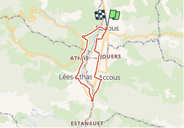
Trail Walking of 12 km to be discovered at New Aquitaine, Pyrénées-Atlantiques, Bedous. This trail is proposed by LouisROGER.
Photos


Positioning
Country:
France
Region :
New Aquitaine
Department/Province :
Pyrénées-Atlantiques
Municipality :
Bedous
Location:
Unknown
Start:(Dec)
Start:(UTM)
695612 ; 4763615 (30T) N.
Comments