


esterençuby fait

LouisROGER
User GUIDE
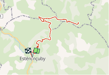

Length
12.8 km

Max alt
725 m

Uphill gradient
575 m
Km-Effort
20 km

Min alt
231 m

Downhill gradient
577 m
Boucle
Yes
Creation date :
2019-09-02 06:57:55.12
Updated on :
2019-09-02 12:41:42.936
5h41
Difficulty : Very easy

FREE GPS app for hiking
 SityTrail
IGN / Geographical institutes
SityTrail Plus
The world is yours!
About
Trail Walking of 12.8 km to be discovered at New Aquitaine, Pyrénées-Atlantiques, Estérençuby. This trail is proposed by LouisROGER.
Photos


Positioning
Country:
France
Region :
New Aquitaine
Department/Province :
Pyrénées-Atlantiques
Municipality :
Estérençuby
Location:
Unknown
Start:(Dec)
Start:(UTM)
646829 ; 4773984 (30T) N.
Comments