


saint-romain 16 03 sept 2019

bert16
User
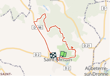

Length
7.8 km

Max alt
140 m

Uphill gradient
130 m
Km-Effort
9.5 km

Min alt
72 m

Downhill gradient
127 m
Boucle
Yes
Creation date :
2019-09-03 07:06:49.576
Updated on :
2019-09-03 09:06:05.962
1h57
Difficulty : Medium

FREE GPS app for hiking
 SityTrail
IGN / Geographical institutes
SityTrail Plus
The world is yours!
About
Trail Walking of 7.8 km to be discovered at New Aquitaine, Charente, Saint-Romain. This trail is proposed by bert16.
Description
asso anciens élèves et amis de brie sous chalais 15 randonneurs
Photos

Positioning
Country:
France
Region :
New Aquitaine
Department/Province :
Charente
Municipality :
Saint-Romain
Location:
Unknown
Start:(Dec)
Start:(UTM)
276370 ; 5017499 (31T) N.
Comments