Trail Walking Labelle - 2014-05-25 16:07:40 - Photo

2014-05-25 16:07:40

 Alizée.pee
Alizée.pee

User GUIDE

© OpenStreetMap contributors
Length
Length
17.3 km
Max alt
Max alt
546 m
Uphill gradient
Uphill gradient
777 m
Km-Effort
Km-Effort  
28 km
Min alt
Min alt
267 m
Downhill gradient
Downhill gradient
776 m
Boucle
Boucle
Yes
Creation date :
2019-09-03 13:46:11.024
Updated on :
2019-09-03 13:48:14.389

(1 Reviews)

Walking
Walking
6h40
Difficulty : Very difficult

Scan this QR Code to open this trail in the SityTrail application

FREE GPS app for hiking

Logo SityTrail SityTrail

IGN / Geographical institutes

Download SityTrail from the App Store Download SityTrail from Google Play

Logo SityTrail SityTrail World

The world is yours!

Download SityTrail from the App Store Download SityTrail from Google Play Download SityTrail on Huawei AppGallery

About

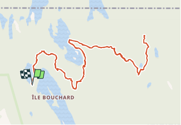
Trail Walking of 17.3 km to be discovered at Quebec, Les Laurentides, Labelle. This trail is proposed by Alizée.pee.

Description

Le sommet du Mont Gorille est assez boisé mais on peut néanmoins apercevoir de superbes panoramas. Le sentier débute au Petit Lac Caribou, passe par la Montagne du Caribou et certains lacs avant de finir au niveau du sommet du Mont Gorille. Cette randonnée permet d’apprécier la beauté des lieux et des paysages.

Elevation profile

Points of interest

Point of interest Labelle - Stationnement - Photo
Alizée.pee
LABELLE 
Point of interest Labelle - Sommet - Mont Gorille - Photo
Alizée.pee
Point of interest Labelle - Sommet - Cap 360 - Photo
Alizée.pee
Point of interest Labelle - Point de vue - Photo
Alizée.pee
LABELLE 
Point of interest Labelle - Début du sentier - Photo
Alizée.pee
Point of interest Labelle - Camping - Photo
Alizée.pee
LABELLE 

Positioning

Country:
Canada
Region :
Quebec
Department/Province :
Les Laurentides
Municipality :
Labelle
Location:
Unknown
Start:(UTM)
521797 ; 5127080 (18T) N.

Comments

Please log in to post a review or rate the element


Merci pour ce partage !


Trails nearby

Trail Walking Labelle - Wikiloc - Lac-Caribou - Cap 360° - Photo
Walking
GUIDE
Alizée.pee

Walking

Medium
Labelle, Quebec, Les Laurentides, Canada
5.8 km | 8.6 km-effort
1h 47min
Yes
Trail Canoe - kayak Labelle - Rivière Rouge - Photo
Canoe - kayak
DaVinci

Canoe - kayak

Medium
Labelle, Quebec, Les Laurentides, Canada
25 km | 27 km-effort
4h 10min
No


Close
My subscriptions