


ger RS 2019

LouisROGER
User GUIDE
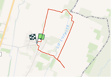

Length
3.9 km

Max alt
399 m

Uphill gradient
33 m
Km-Effort
4.4 km

Min alt
382 m

Downhill gradient
33 m
Boucle
Yes
Creation date :
2019-09-03 12:05:36.895
Updated on :
2019-09-03 13:51:46.97
1h44
Difficulty : Very easy

FREE GPS app for hiking
 SityTrail
IGN / Geographical institutes
SityTrail Plus
The world is yours!
About
Trail Walking of 3.9 km to be discovered at New Aquitaine, Pyrénées-Atlantiques, Ger. This trail is proposed by LouisROGER.
Positioning
Country:
France
Region :
New Aquitaine
Department/Province :
Pyrénées-Atlantiques
Municipality :
Ger
Location:
Unknown
Start:(Dec)
Start:(UTM)
740444 ; 4795009 (30T) N.
Comments