


lac des tempetes

Liebeaux
User
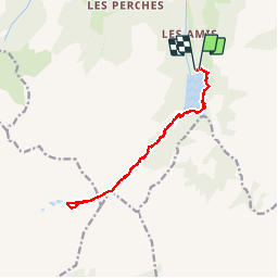

Length
14.1 km

Max alt
2172 m

Uphill gradient
834 m
Km-Effort
25 km

Min alt
1535 m

Downhill gradient
847 m
Boucle
Yes
Creation date :
2019-09-05 07:12:56.768
Updated on :
2019-09-05 14:52:02.889
6h12
Difficulty : Very easy

FREE GPS app for hiking
 SityTrail
IGN / Geographical institutes
SityTrail Plus
The world is yours!
About
Trail Walking of 14.1 km to be discovered at Auvergne-Rhône-Alpes, Savoy, Beaufort. This trail is proposed by Liebeaux.
Positioning
Country:
France
Region :
Auvergne-Rhône-Alpes
Department/Province :
Savoy
Municipality :
Beaufort
Location:
Unknown
Start:(Dec)
Start:(UTM)
311576 ; 5058148 (32T) N.
Comments