


champsaur 2020;de saint philippe au chapeau de napoleon

gerardmicheline
User
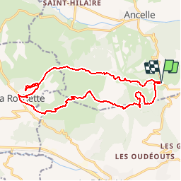

Length
17.4 km

Max alt
1687 m

Uphill gradient
698 m
Km-Effort
27 km

Min alt
1137 m

Downhill gradient
700 m
Boucle
Yes
Creation date :
2019-09-08 16:18:53.179
Updated on :
2019-09-08 16:20:54.478
5h32
Difficulty : Very difficult

FREE GPS app for hiking
 SityTrail
IGN / Geographical institutes
SityTrail Plus
The world is yours!
About
Trail Walking of 17.4 km to be discovered at Provence-Alpes-Côte d'Azur, Hautes-Alpes, Ancelle. This trail is proposed by gerardmicheline.
Positioning
Country:
France
Region :
Provence-Alpes-Côte d'Azur
Department/Province :
Hautes-Alpes
Municipality :
Ancelle
Location:
Unknown
Start:(Dec)
Start:(UTM)
279395 ; 4942286 (32T) N.
Comments