Trail Walking Piencourt - Piencourt - Chemin des manoirs- 14,5 km - Photo

Piencourt - Chemin des manoirs- 14,5 km

© OpenStreetMap contributors
Length
Length
14.5 km
Max alt
Max alt
170 m
Uphill gradient
Uphill gradient
144 m
Km-Effort
Km-Effort  
16.5 km
Min alt
Min alt
111 m
Downhill gradient
Downhill gradient
143 m
Boucle
Boucle
Yes
Creation date :
2019-09-12 08:17:47.555
Updated on :
2019-09-12 13:57:41.677

(0 Reviews)

Walking
Walking
4h56
Difficulty : Very easy

Scan this QR Code to open this trail in the SityTrail application

FREE GPS app for hiking

Logo SityTrail SityTrail

IGN / Geographical institutes

Download SityTrail from the App Store Download SityTrail from Google Play

Logo SityTrail SityTrail World

The world is yours!

Download SityTrail from the App Store Download SityTrail from Google Play Download SityTrail on Huawei AppGallery

About

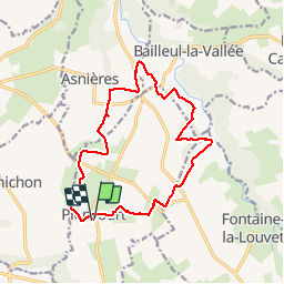
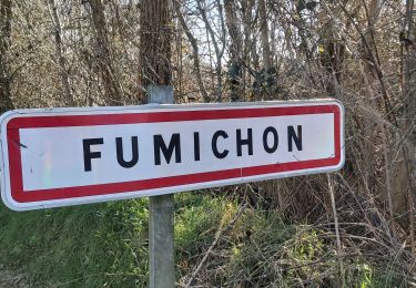
Trail Walking of 14.5 km to be discovered at Normandy, Eure, Piencourt. This trail is proposed by MichelRando7656.

Description

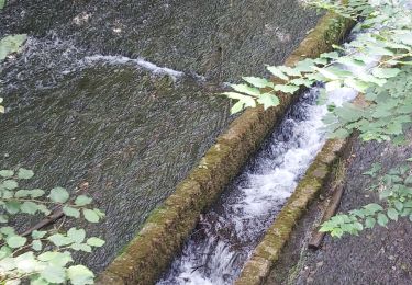
Beau parcours composé de petites  ruelles gravillonnées , de superbes  sentiers variés de plaine ou de chemins creux bordés par de très belles maisons à colombages.
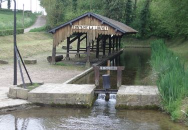
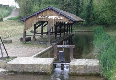
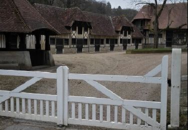
Sur notre chemin, le superbe haras de " La Rivière ", près de la La Calonne.
Bonnes et grosses mûres à déguster au mois de septembre.

Elevation profile

Photos

Positioning

Country:
France
Region :
Normandy
Department/Province :
Eure
Municipality :
Piencourt
Location:
Unknown
Start:(UTM)
310392 ; 5449237 (31U) N.

Trails nearby

Trail Walking Piencourt - Piencourt - Photo
Walking
Eve - Line

Walking

Easy
Piencourt, Normandy, Eure, France
11.7 km | 13.2 km-effort
2h 36min
Yes
Trail Walking Fontaine-la-Louvet - Circuit de la Calonne  - Fontaine-la-Louvet - Photo
Walking
tracegps

Walking

Medium
Fontaine-la-Louvet, Normandy, Eure, France
8.2 km | 9.8 km-effort
2h 0min
Yes
Trail Cycle Fontaine-la-Louvet - Boucle du Haras de Piencourt  - Fontaine la Louvet - Photo
Cycle
tracegps

Cycle

Easy
Fontaine-la-Louvet, Normandy, Eure, France
15.3 km | 17.1 km-effort
1h 0min
Yes
Trail Walking Bailleul-la-Vallée - Bailleul la Vallée : la randonnée qui monte  - Photo
Walking
jluclem

Walking

Difficult
Bailleul-la-Vallée, Normandy, Eure, France
11.1 km | 13.1 km-effort
2h 39min
Yes
Trail Walking Fumichon - Fumichon - Photo
Walking
Eve - Line

Walking

Medium
(1)
Fumichon, Normandy, Calvados, France
13.9 km | 16.4 km-effort
2h 43min
Yes
Trail Walking Moyaux - Moyaux - Photo
Walking
Eve - Line

Walking

Easy
Moyaux, Normandy, Calvados, France
11.8 km | 12.8 km-effort
2h 17min
Yes
Trail Walking Bailleul-la-Vallée - bailleul la vallée raccourcie - Photo
Walking
ymarvin27

Walking

Easy
Bailleul-la-Vallée, Normandy, Eure, France
7.7 km | 9.3 km-effort
1h 40min
Yes
Trail Running Fresne-Cauverville - Chemin de la Forge Subtile - Fresne Cauverville - Photo
Running
tracegps

Running

Medium
Fresne-Cauverville, Normandy, Eure, France
5.1 km | 5.9 km-effort
40min
Yes
Trail Mountain bike Fresne-Cauverville - Chemin de la Forge Subtile - Fresne Cauverville - Photo
Mountain bike
tracegps

Mountain bike

Easy
Fresne-Cauverville, Normandy, Eure, France
5.1 km | 5.9 km-effort
30min
Yes


Close
My subscriptions