Trail Walking Orsières - grand et petit col ferret - Photo

grand et petit col ferret

 duamerg
duamerg

User

© OpenStreetMap contributors
Length
Length
17.2 km
Max alt
Max alt
2560 m
Uphill gradient
Uphill gradient
1016 m
Km-Effort
Km-Effort  
31 km
Min alt
Min alt
1775 m
Downhill gradient
Downhill gradient
1018 m
Boucle
Boucle
Yes
Creation date :
2014-12-11 00:00:00.0
Updated on :
2020-01-30 13:58:53.295

(0 Reviews)

Walking
Walking
6h00
Difficulty : Medium

Scan this QR Code to open this trail in the SityTrail application

FREE GPS app for hiking

Logo SityTrail SityTrail

IGN / Geographical institutes

Download SityTrail from the App Store Download SityTrail from Google Play

Logo SityTrail SityTrail World

The world is yours!

Download SityTrail from the App Store Download SityTrail from Google Play Download SityTrail on Huawei AppGallery

About

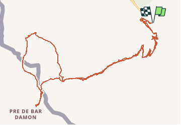
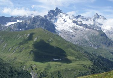
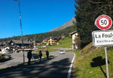
Trail Walking of 17.2 km to be discovered at Valais/Wallis, Entremont, Orsières. This trail is proposed by duamerg.

Description

partir du parking et monter au grand col Ferret 2525m. Pour avoir une meilleure vue, redescendre un peu sur le versant italien. Revenir au col et suivre le tracé sur le versant italien pour rejoindre le petit col Ferret. Rejoindre le point 1425 et rejoindre le chemin du grand col Ferret par le point 1495m. Ce tracé n''est pas un balisage officiel. Retour à la voiture.

Elevation profile

Positioning

Country:
Switzerland
Region :
Valais/Wallis
Department/Province :
Entremont
Municipality :
Orsières
Location:
Unknown
Start:(UTM)
353881 ; 5085273 (32T) N.

Trails nearby

Trail Walking Bourg-Saint-Pierre - st. Bernard - Photo
Walking
PurroB

Walking

Very easy
(2)
Bourg-Saint-Pierre, Valais/Wallis, Entremont, Switzerland
44 km | 116 km-effort
6h 17min
No
Trail On foot Bourg-Saint-Pierre - Chemins pédestres, région St-Bernard - Photo
On foot
PRO

On foot

Easy
Bourg-Saint-Pierre, Valais/Wallis, Entremont, Switzerland
8.6 km | 18.8 km-effort
4h 15min
No
Trail On foot Bourg-Saint-Pierre - Via Alpina Red R117 - Photo
On foot
PRO

On foot

Very difficult
Bourg-Saint-Pierre, Valais/Wallis, Entremont, Switzerland
27 km | 46 km-effort
10h 25min
No
Trail On foot Orsières - Trail Verbier St-Bernard - Traversée - Photo
On foot
PRO

On foot

Very difficult
Orsières, Valais/Wallis, Entremont, Switzerland
37 km | 70 km-effort
15h 47min
No
Trail On foot Orsières - Sentier des Bergers - Photo
On foot
PRO

On foot

Easy
Orsières, Valais/Wallis, Entremont, Switzerland
4.8 km | 9.2 km-effort
2h 5min
No
Trail Walking Courmayeur - TMB J4 Ref.ELENA - COURMAYEUR - Photo
Walking
GerardBouche

Walking

Medium
Courmayeur, Aosta Valley, Unknown, Italy
13.5 km | 22 km-effort
4h 18min
No
Trail Walking Courmayeur - TMB day 4 - Photo
Walking
elixpomatia

Walking

Medium
Courmayeur, Aosta Valley, Unknown, Italy
16.6 km | 27 km-effort
5h 37min
No
Trail Walking Orsières - La Fouly, Randonée hivernale, Sentier de l''Amône  - Photo
Walking
verbier

Walking

Very easy
(1)
Orsières, Valais/Wallis, Entremont, Switzerland
1.9 km | 2.7 km-effort
50min
Yes
Trail Walking Orsières - ferret La Foully - Photo
Walking
michauxpaul

Walking

Medium
Orsières, Valais/Wallis, Entremont, Switzerland
4.6 km | 6.1 km-effort
2h 20min
No


Close
My subscriptions