Trail On foot Paillart - Les voies romaines depuis Paillart - Photo

Les voies romaines depuis Paillart

 fitz2014
fitz2014

User

© OpenStreetMap contributors
Length
Length
8.7 km
Max alt
Max alt
111 m
Uphill gradient
Uphill gradient
110 m
Km-Effort
Km-Effort  
10.2 km
Min alt
Min alt
69 m
Downhill gradient
Downhill gradient
110 m
Boucle
Boucle
Yes
Creation date :
2019-09-15 10:28:34.726
Updated on :
2019-09-15 10:30:31.169

(0 Reviews)

On foot
On foot
--
Difficulty : Very easy

Scan this QR Code to open this trail in the SityTrail application

FREE GPS app for hiking

Logo SityTrail SityTrail

IGN / Geographical institutes

Download SityTrail from the App Store Download SityTrail from Google Play

Logo SityTrail SityTrail World

The world is yours!

Download SityTrail from the App Store Download SityTrail from Google Play Download SityTrail on Huawei AppGallery

About

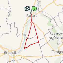
Trail On foot of 8.7 km to be discovered at Hauts-de-France, Oise, Paillart. This trail is proposed by fitz2014.

Description

Reliée à deux célèbres voies romaines, parcourez la Chaussée Brunehaut et la Via Agrippa,

Elevation profile

Positioning

Country:
France
Region :
Hauts-de-France
Department/Province :
Oise
Municipality :
Paillart
Location:
Unknown
Start:(UTM)
451182 ; 5501937 (31U) N.

Trails nearby

Trail Walking Folleville - Folleville  - Photo
Walking
jema.bernard

Walking

Very easy
Folleville, Hauts-de-France, Somme, France
6.1 km | 7.5 km-effort
1h 25min
Yes
Trail Other activity Bacouël - Picardie - Ligne 319 - Breteuil-Embranchement - Breteuil-Ville - Photo
Other activity
mich54

Other activity

Very easy
Bacouël, Hauts-de-France, Oise, France
6.9 km | 7.5 km-effort
5min
No
Trail Motor La Faloise - Balade La Faloise / Guizancourt - Photo
Motor
yoann80250

Motor

Difficult
La Faloise, Hauts-de-France, Somme, France
80 km | 95 km-effort
2h 0min
Yes
Trail Walking Bacouël - St Jacques le Majeur - Photo
Walking
Cheyenne80

Walking

Medium
Bacouël, Hauts-de-France, Oise, France
14 km | 16.7 km-effort
3h 37min
No
Trail Walking Lawarde-Mauger-l'Hortoy - Les Longues Avoines - Photo
Walking
sulcata80

Walking

Medium
Lawarde-Mauger-l'Hortoy, Hauts-de-France, Somme, France
7.6 km | 9.2 km-effort
1h 58min
Yes
Trail Walking La Faloise - La Chaussée - Photo
Walking
sulcata80

Walking

Medium
La Faloise, Hauts-de-France, Somme, France
14.4 km | 17.7 km-effort
3h 49min
Yes
Trail Walking La Faloise - Autour de Courcelles - Photo
Walking
sulcata80

Walking

Easy
La Faloise, Hauts-de-France, Somme, France
6.2 km | 7.2 km-effort
1h 35min
Yes


Close
My subscriptions