Trail Walking Villers-la-Ville - RB-Bw-10-raccourci 2 - À travers campagnes et forêts, autour des ruines d’une prestigieuse abbaye - Photo

RB-Bw-10-raccourci 2 - À travers campagnes et forêts, autour des ruines d’une prestigieuse abbaye

Randonnez sur et autour des GR ® wallons (Sentiers de Grande Randonnée). PRO

© OpenStreetMap contributors
Length
Length
13.3 km
Max alt
Max alt
164 m
Uphill gradient
Uphill gradient
238 m
Km-Effort
Km-Effort  
16.4 km
Min alt
Min alt
85 m
Downhill gradient
Downhill gradient
240 m
Boucle
Boucle
Yes
Creation date :
2019-08-07 07:24:54.868
Updated on :
2023-10-23 15:08:26.079

(25 Reviews)

Walking
Walking
3h44
Difficulty : Difficult

Scan this QR Code to open this trail in the SityTrail application

FREE GPS app for hiking

Logo SityTrail SityTrail

IGN / Geographical institutes

Download SityTrail from the App Store Download SityTrail from Google Play

Logo SityTrail SityTrail World

The world is yours!

Download SityTrail from the App Store Download SityTrail from Google Play Download SityTrail on Huawei AppGallery

About

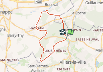
Trail Walking of 13.3 km to be discovered at Wallonia, Walloon Brabant, Villers-la-Ville. This trail is proposed by GR Rando.

Description

Villers-la-Ville, Sart-Dames-Avelines, Villers-la-Ville

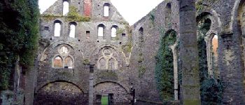
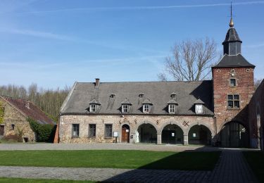
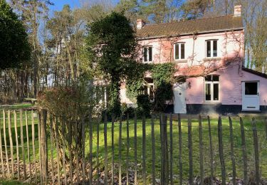
Une balade aux multiples facettes, particulièrement éloignée des axes fréquentés. Vous évoluez dans de vastes espaces champêtres, parmi de séduisants vallons, au sein de plusieurs massifs boisés. Beaucoup de larges horizons et, en prime, le site fascinant des ruines de l'abbaye de Villers.

Cartographie et documentation
Cartes IGN au 1 :20 000, 39/7-8 « Nivelles – Genappe » et 40/5-6 « Chastre –
Gembloux».
Carte de promenades « Villers-la-Ville » au 1:20 000, éditée par le Syndicat d’initiative
de Villers-la-Ville en collaboration avec l’IGN.
Carte de promenades « Genappe » au 1:25 000, éditée par le Syndicat d’initiative de Genappe en collaboration avec l’IGN.
Topo-guide du GR 12 « Amsterdam – Bruxelles – Paris » et du GR 121 « Wavre –
Boulogne-sur-Mer ».
Topo-guide du GR 126 « Bruxelles – Namur – Membre-sur-Semois ».

Où se désaltérer et se restaurer
Près des ruines de Villers-la-Ville, le « Chalet de la Forêt » et, de l’autre côté du site, le « Moulin de Villers », une taverne-restaurant, offrent tous deux une possibilité de petite restauration.
À l’entrée du village de Villers-la-Ville, à environ un kilomètre des ruines, le restaurant « Le Cigalon ».

Photos

Points of interest

Point of interest Villers-la-Ville - l’abbaye de Villers - Photo
GR Rando
VILLERS-LA-VILLE 
Point of interest Villers-la-Ville - La Thyle - Photo
GR Rando
VILLERS-LA-VILLE 
Point of interest Villers-la-Ville - château « Le Châtelet - Photo
GR Rando
VILLERS-LA-VILLE 
Point of interest Villers-la-Ville - Le moulin d’Hollers - Photo
GR Rando
VILLERS-LA-VILLE 
Point of interest Villers-la-Ville - Sart-Dames-Avelines - Photo
GR Rando
VILLERS-LA-VILLE 
Point of interest Villers-la-Ville - L’église Notre-Dame de la Visitation - Photo
GR Rando

Positioning

Country:
Belgium
Region :
Wallonia
Department/Province :
Walloon Brabant
Municipality :
Villers-la-Ville
Location:
Villers-la-Ville
Start:(UTM)
608090 ; 5605433 (31U) N.

Comments

Please log in to post a review or rate the element


Chouetts paysage


Chouette rando. un peu trop de route à mon goût mais aussi non sympa ??


Superbe balade


Vari? et agr?able, passe pr?s de plusieurs b?timents remarquables.


ne s agit il pas du raccourci 1 ?


Chouette balade. paysages diversifi?s. Tr?s agr?able.Par ailleurs, excellente appli. Dommage qu'il n'y ait pas de chrono pour mesurer le temps de parcours,la vitesse moyenne etc.


Très beau circuit


complet, ? d?couvrir.


Super


Super


Trails nearby

Trail Walking Villers-la-Ville - RB-Bw-10-raccourci 1 - À travers campagnes et forêts, autour des ruines d’une prestigieuse abbaye  - Photo
Walking
PRO

Walking

Very difficult
(12)
Villers-la-Ville, Wallonia, Walloon Brabant, Belgium
24 km | 30 km-effort
6h 43min
Yes
Trail Walking Genappe - RB-Bw-09 Raccourci 1 & 2 - Autour de la jeune Dyle et de ses affluents - Photo
Walking
PRO

Walking

Difficult
(11)
Genappe, Wallonia, Walloon Brabant, Belgium
9.7 km | 12.5 km-effort
2h 50min
Yes
Trail Walking Genappe - RB-Bw-09 Raccourci 1 - Autour de la jeune Dyle et de ses affluents - Photo
Walking
PRO

Walking

Difficult
(11)
Genappe, Wallonia, Walloon Brabant, Belgium
13.2 km | 16.9 km-effort
3h 49min
Yes
Trail Walking Villers-la-Ville - RB-Bw-10 -À travers campagnes et forêts, autour des ruines d’une prestigieuse abbaye  - Photo
Walking
PRO

Walking

Very difficult
(6)
Villers-la-Ville, Wallonia, Walloon Brabant, Belgium
26 km | 32 km-effort
7h 15min
Yes
Trail Walking Genappe - RB-Bw-09 - Autour de la jeune Dyle et de ses affluents - Photo
Walking
PRO

Walking

Medium
(9)
Genappe, Wallonia, Walloon Brabant, Belgium
22 km | 28 km-effort
5h 59min
Yes
Trail Walking Genappe - Genappe - Circuit Natura 2000, des sites qui valent le détour ! - Bw03 - Photo
Walking
GUIDE+

Walking

Medium
(6)
Genappe, Wallonia, Walloon Brabant, Belgium
7.9 km | 9.7 km-effort
2h 6min
Yes
Trail Walking Court-Saint-Étienne - GG2-Bw-22_La-Roche-Blanmont_2021-11-04 - Photo
Walking
PRO

Walking

Medium
(2)
Court-Saint-Étienne, Wallonia, Walloon Brabant, Belgium
21 km | 26 km-effort
5h 51min
No
Trail Walking Villers-la-Ville - Balade forestière à Villers la Ville - Photo
Walking
GUIDE
Desrumaux

Walking

Easy
(5)
Villers-la-Ville, Wallonia, Walloon Brabant, Belgium
11.5 km | 14.1 km-effort
3h 0min
Yes
Trail Walking Court-Saint-Étienne - #240304 - La Roche, bois Ste Catherine et du Sartage - Photo
Walking
Randos Ouvertes

Walking

Medium
(1)
Court-Saint-Étienne, Wallonia, Walloon Brabant, Belgium
5.8 km | 7.6 km-effort
1h 42min
Yes


Close
My subscriptions