Trail Horseback riding Saint-Quentin-en-Tourmont - La Maye - Photo
 liebniz
liebniz

User

© OpenStreetMap contributors
Length
Length
12.3 km
Max alt
Max alt
13 m
Uphill gradient
Uphill gradient
46 m
Km-Effort
Km-Effort  
13 km
Min alt
Min alt
-1 m
Downhill gradient
Downhill gradient
50 m
Boucle
Boucle
No
Creation date :
2019-09-15 14:51:44.0
Updated on :
2019-09-18 14:17:42.263

(0 Reviews)

Horseback riding
Horseback riding
2h43
Difficulty : Unknown

Scan this QR Code to open this trail in the SityTrail application

FREE GPS app for hiking

Logo SityTrail SityTrail

IGN / Geographical institutes

Download SityTrail from the App Store Download SityTrail from Google Play

Logo SityTrail SityTrail World

The world is yours!

Download SityTrail from the App Store Download SityTrail from Google Play Download SityTrail on Huawei AppGallery

About

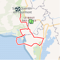
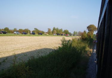
Trail Horseback riding of 12.3 km to be discovered at Hauts-de-France, Somme, Saint-Quentin-en-Tourmont. This trail is proposed by liebniz.

Description

Ne peut etre fait qu'a marée basse puisqu'il faut traverser la maye

Elevation profile

Positioning

Country:
France
Region :
Hauts-de-France
Department/Province :
Somme
Municipality :
Saint-Quentin-en-Tourmont
Location:
Unknown
Start:(UTM)
400151 ; 5569058 (31U) N.

Comments

Please log in to post a review or rate the element


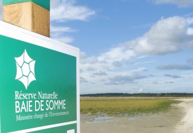
ATTENTION une partie du circuit traverse la réserve naturelle nationale de baie de Somme avec sa réglementation propre notamment l'interdiction des chiens toute l'année et interdiction de déranger la faune


Trails nearby

Trail Walking Le Crotoy - CDT80-3 - Photo
Walking

Walking

Medium
(2)
Le Crotoy, Hauts-de-France, Somme, France
6 km | 6.1 km-effort
1h 23min
Yes
Trail Walking Saint-Quentin-en-Tourmont - Les crocs - Saint Quentin en Tourmont - Photo
Walking
tracegps

Walking

Difficult
(4)
Saint-Quentin-en-Tourmont, Hauts-de-France, Somme, France
15.8 km | 16.9 km-effort
5h 30min
Yes
Trail Walking Favières - Circuit de Morlay - Photo
Walking
tracegps

Walking

Difficult
(1)
Favières, Hauts-de-France, Somme, France
12.4 km | 12.8 km-effort
4h 0min
Yes
Trail Equestrian Le Crotoy - de la Maye vers marquenterre - Photo
Equestrian
ioudina

Equestrian

Very easy
(4)
Le Crotoy, Hauts-de-France, Somme, France
20 km | 21 km-effort
2h 43min
No
Trail Walking Le Crotoy - traversée baie somme et train - Photo
Walking
lefrancm

Walking

Very easy
(1)
Le Crotoy, Hauts-de-France, Somme, France
24 km | 25 km-effort
6h 58min
No
Trail Walking Le Crotoy - La Maille - Pointe de St Quentin - Photo
Walking
tbrunet

Walking

Medium
Le Crotoy, Hauts-de-France, Somme, France
9 km | 9.1 km-effort
4h 30min
Yes
Trail On foot Le Crotoy - Balade au Crotoy - Photo
On foot
PRO

On foot

Easy
Le Crotoy, Hauts-de-France, Somme, France
9.9 km | 10.4 km-effort
2h 22min
Yes
Trail On foot  - Les Crocs - Photo
On foot
PRO

On foot

Easy
, , , France
16.1 km | 17.1 km-effort
3h 53min
Yes
Trail On foot Favières - Circuit de Morlay - Photo
On foot
PRO

On foot

Easy
Favières, Hauts-de-France, Somme, France
10.8 km | 11.2 km-effort
2h 32min
No


Close
My subscriptions