


circuit vtt Poitiers Sud

topolino
User
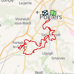

Length
43 km

Max alt
154 m

Uphill gradient
644 m
Km-Effort
52 km

Min alt
73 m

Downhill gradient
643 m
Boucle
Yes
Creation date :
2019-09-16 10:23:15.403
Updated on :
2019-09-16 10:24:45.824
3h25
Difficulty : Difficult

FREE GPS app for hiking
 SityTrail
IGN / Geographical institutes
SityTrail Plus
The world is yours!
About
Trail Mountain bike of 43 km to be discovered at New Aquitaine, Vienne, Poitiers. This trail is proposed by topolino.
Positioning
Country:
France
Region :
New Aquitaine
Department/Province :
Vienne
Municipality :
Poitiers
Location:
Unknown
Start:(Dec)
Start:(UTM)
295919 ; 5161410 (31T) N.
Comments