Trail Walking Céligny - Céligny - Versoix en suivant la rivière - Photo

Céligny - Versoix en suivant la rivière

 duamerg
duamerg

User

© OpenStreetMap contributors
Length
Length
20 km
Max alt
Max alt
485 m
Uphill gradient
Uphill gradient
245 m
Km-Effort
Km-Effort  
23 km
Min alt
Min alt
391 m
Downhill gradient
Downhill gradient
245 m
Boucle
Boucle
No
Creation date :
2014-12-11 00:00:00.0
Updated on :
2020-01-30 13:58:21.494

(0 Reviews)

Walking
Walking
5h21
Difficulty : Medium

Scan this QR Code to open this trail in the SityTrail application

FREE GPS app for hiking

Logo SityTrail SityTrail

IGN / Geographical institutes

Download SityTrail from the App Store Download SityTrail from Google Play

Logo SityTrail SityTrail World

The world is yours!

Download SityTrail from the App Store Download SityTrail from Google Play Download SityTrail on Huawei AppGallery

About

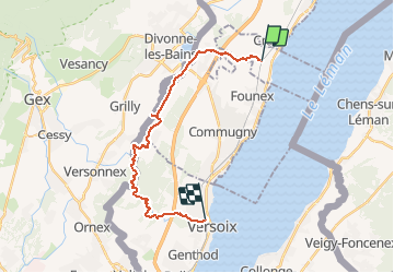
Trail Walking of 20 km to be discovered at Geneva, Unknown, Céligny. This trail is proposed by duamerg.

Description

Laisser la voiture à Céligny gare. Suivre les indications pour le château de Bossey :). Jusqu'à Bogis et Chavannes de Bogis (goudron):(. En longeant déjà la Versoix, continuer jusqu'à Chavannes des Bois et Sauverny-Genève. Depuis cet endroit on longe la rivière. Bonnes chaussures recommandées. Au premier pont pour véhicules, rester sur la même rive (mal indiqué). Un chemin existe sur l'autre rive mais est un peu casse cou!Prendre le train pour rejoindre Céligny.

Elevation profile

Positioning

Country:
Switzerland
Region :
Geneva
Department/Province :
Unknown
Municipality :
Céligny
Location:
Unknown
Start:(UTM)
284589 ; 5136588 (32T) N.

Trails nearby

Trail Walking Divonne-les-Bains - 20230521 - Divonne-les-Bains 3.8 Km - Photo
Walking
GUIDE
pierreh01

Walking

Easy
Divonne-les-Bains, Auvergne-Rhône-Alpes, Ain, France
3.8 km | 4.1 km-effort
56min
Yes
Trail Walking Divonne-les-Bains - Randonnée - Photo
Walking
GUIDE
pierreh01

Walking

Medium
Divonne-les-Bains, Auvergne-Rhône-Alpes, Ain, France
6.2 km | 9 km-effort
2h 2min
Yes
Trail Cycle Nyon - Nyon - Lignerolle - Photo
Cycle
karawatsj

Cycle

Very difficult
Nyon, Vaud, District de Nyon, Switzerland
69 km | 89 km-effort
4h 58min
No
Trail Other activity Hermance - bdr20_Heremence_StGingolphe - Photo
Other activity
GUIDE+

Other activity

Very easy
Hermance, Geneva, Unknown, Switzerland
59 km | 59 km-effort
Unknown
No
Trail Other activity Hermance - xxx19_GVA_Heremence - Photo
Other activity
GUIDE+

Other activity

Very easy
Hermance, Geneva, Unknown, Switzerland
89 km | 103 km-effort
23h 26min
No
Trail Walking Nyon - w_CHpur05_toblerone - Photo
Walking
GUIDE+

Walking

Very easy
(1)
Nyon, Vaud, District de Nyon, Switzerland
16.1 km | 21 km-effort
Unknown
No
Trail Cycle Prangins - ST_par_typ_2 - Photo
Cycle
GUIDE+

Cycle

Very easy
Prangins, Vaud, District de Nyon, Switzerland
281 km | 403 km-effort
4h 47min
No
Trail Cycle Nyon - ST_par_typ_hot09 - Photo
Cycle
GUIDE+

Cycle

Very easy
(1)
Nyon, Vaud, District de Nyon, Switzerland
278 km | 375 km-effort
6h 26min
No
Trail Walking Nyon - st_ral_08_2 - Photo
Walking
GUIDE+

Walking

Very easy
Nyon, Vaud, District de Nyon, Switzerland
36 km | 41 km-effort
1h 21min
No


Close
My subscriptions