


Lutter Feldbach Ilfis Lutter

gerando
User
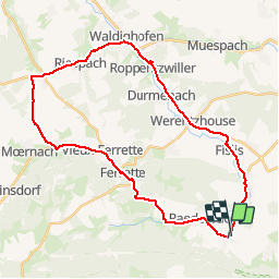

Length
33 km

Max alt
598 m

Uphill gradient
440 m
Km-Effort
39 km

Min alt
345 m

Downhill gradient
446 m
Boucle
No
Creation date :
2019-09-23 09:41:20.498
Updated on :
2019-09-23 09:42:57.326
2h00
Difficulty : Very easy

FREE GPS app for hiking
 SityTrail
IGN / Geographical institutes
SityTrail Plus
The world is yours!
About
Trail Cycle of 33 km to be discovered at Grand Est, Haut-Rhin, Lutter. This trail is proposed by gerando.
Positioning
Country:
France
Region :
Grand Est
Department/Province :
Haut-Rhin
Municipality :
Lutter
Location:
Unknown
Start:(Dec)
Start:(UTM)
377961 ; 5258318 (32T) N.
Comments