


lac arpon

JPS73
User
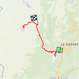

Length
9.3 km

Max alt
2700 m

Uphill gradient
1342 m
Km-Effort
24 km

Min alt
1354 m

Downhill gradient
394 m
Boucle
No
Creation date :
2019-09-17 06:10:01.09
Updated on :
2019-09-26 04:38:30.398
4h47
Difficulty : Very easy

FREE GPS app for hiking
 SityTrail
IGN / Geographical institutes
SityTrail Plus
The world is yours!
About
Trail Walking of 9.3 km to be discovered at Auvergne-Rhône-Alpes, Savoy, Val-Cenis. This trail is proposed by JPS73.
Positioning
Country:
France
Region :
Auvergne-Rhône-Alpes
Department/Province :
Savoy
Municipality :
Val-Cenis
Location:
Termignon
Start:(Dec)
Start:(UTM)
328476 ; 5017941 (32T) N.
Comments