


Durmenach Oltingue

ffdur
User
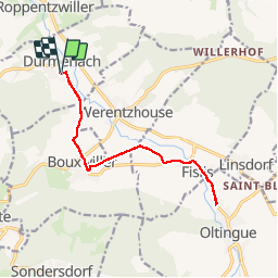

Length
13.8 km

Max alt
400 m

Uphill gradient
93 m
Km-Effort
15 km

Min alt
362 m

Downhill gradient
93 m
Boucle
Yes
Creation date :
2019-09-27 04:19:44.829
Updated on :
2019-09-27 07:20:50.096
3h00
Difficulty : Very easy

FREE GPS app for hiking
 SityTrail
IGN / Geographical institutes
SityTrail Plus
The world is yours!
About
Trail Walking of 13.8 km to be discovered at Grand Est, Haut-Rhin, Durmenach. This trail is proposed by ffdur.
Positioning
Country:
France
Region :
Grand Est
Department/Province :
Haut-Rhin
Municipality :
Durmenach
Location:
Unknown
Start:(Dec)
Start:(UTM)
374926 ; 5264837 (32T) N.
Comments