


Vauvenargues - Puits d'Auzon

mhetpierre
User
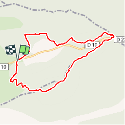

Length
9.1 km

Max alt
694 m

Uphill gradient
217 m
Km-Effort
12 km

Min alt
496 m

Downhill gradient
220 m
Boucle
Yes
Creation date :
2019-09-27 07:52:24.129
Updated on :
2019-09-27 15:52:41.346
2h41
Difficulty : Very easy

FREE GPS app for hiking
 SityTrail
IGN / Geographical institutes
SityTrail Plus
The world is yours!
About
Trail Walking of 9.1 km to be discovered at Provence-Alpes-Côte d'Azur, Bouches-du-Rhône, Vauvenargues. This trail is proposed by mhetpierre.
Positioning
Country:
France
Region :
Provence-Alpes-Côte d'Azur
Department/Province :
Bouches-du-Rhône
Municipality :
Vauvenargues
Location:
Unknown
Start:(Dec)
Start:(UTM)
715906 ; 4825414 (31T) N.
Comments