


col lindar,morbié,mont pelat

lecmic
User
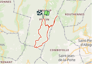

Length
13.9 km

Max alt
1535 m

Uphill gradient
707 m
Km-Effort
23 km

Min alt
979 m

Downhill gradient
706 m
Boucle
Yes
Creation date :
2019-09-27 07:05:59.229
Updated on :
2019-09-27 12:22:49.705
4h10
Difficulty : Medium

FREE GPS app for hiking
 SityTrail
IGN / Geographical institutes
SityTrail Plus
The world is yours!
About
Trail Walking of 13.9 km to be discovered at Auvergne-Rhône-Alpes, Savoy, Aillon-le-Jeune. This trail is proposed by lecmic.
Positioning
Country:
France
Region :
Auvergne-Rhône-Alpes
Department/Province :
Savoy
Municipality :
Aillon-le-Jeune
Location:
Unknown
Start:(Dec)
Start:(UTM)
273412 ; 5052780 (32T) N.
Comments