


ousseH4G3fait

LouisROGER
User GUIDE
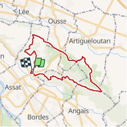

Length
15.2 km

Max alt
404 m

Uphill gradient
413 m
Km-Effort
21 km

Min alt
214 m

Downhill gradient
414 m
Boucle
Yes
Creation date :
2019-10-03 07:07:16.825
Updated on :
2019-10-03 13:03:58.82
5h54
Difficulty : Very easy

FREE GPS app for hiking
 SityTrail
IGN / Geographical institutes
SityTrail Plus
The world is yours!
About
Trail Walking of 15.2 km to be discovered at New Aquitaine, Pyrénées-Atlantiques, Assat. This trail is proposed by LouisROGER.
Positioning
Country:
France
Region :
New Aquitaine
Department/Province :
Pyrénées-Atlantiques
Municipality :
Assat
Location:
Unknown
Start:(Dec)
Start:(UTM)
720392 ; 4792881 (30T) N.
Comments