


jour 26 CAP jeanot

jeannat
User

Length
29 km

Max alt
95 m

Uphill gradient
353 m
Km-Effort
34 km

Min alt
3 m

Downhill gradient
394 m
Boucle
No
Creation date :
2019-10-04 11:29:37.726
Updated on :
2019-10-04 16:44:09.609
5h13
Difficulty : Very easy

FREE GPS app for hiking
 SityTrail
IGN / Geographical institutes
SityTrail Plus
The world is yours!
About
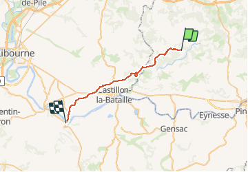
Trail Walking of 29 km to be discovered at New Aquitaine, Dordogne, Montpeyroux. This trail is proposed by jeannat.
Description
de Montpeyroux à St Jean de Blaignac
Positioning
Country:
France
Region :
New Aquitaine
Department/Province :
Dordogne
Municipality :
Montpeyroux
Location:
Unknown
Start:(Dec)
Start:(UTM)
270349 ; 4977814 (31T) N.
Comments