


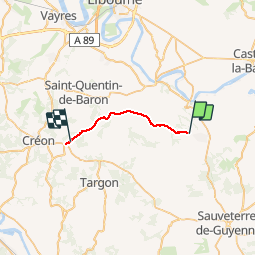
de St Jean de Blaignac à La Sauve

jeannat
User

Length
16.8 km

Max alt
108 m

Uphill gradient
233 m
Km-Effort
19.9 km

Min alt
12 m

Downhill gradient
234 m
Boucle
No
Creation date :
2019-10-04 17:09:55.658
Updated on :
2019-10-04 21:44:36.035
4h33
Difficulty : Very easy

FREE GPS app for hiking
 SityTrail
IGN / Geographical institutes
SityTrail Plus
The world is yours!
About
Trail Car of 16.8 km to be discovered at New Aquitaine, Gironde, Jugazan. This trail is proposed by jeannat.
Positioning
Country:
France
Region :
New Aquitaine
Department/Province :
Gironde
Municipality :
Jugazan
Location:
Unknown
Start:(Dec)
Start:(UTM)
726235 ; 4962629 (30T) N.
Comments