


autour de Montgilbert

laurentnecca
User
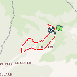

Length
5.5 km

Max alt
1528 m

Uphill gradient
299 m
Km-Effort
9.6 km

Min alt
1256 m

Downhill gradient
312 m
Boucle
Yes
Creation date :
2019-10-08 12:00:27.488
Updated on :
2019-10-08 16:50:20.395
2h06
Difficulty : Easy

FREE GPS app for hiking
 SityTrail
IGN / Geographical institutes
SityTrail Plus
The world is yours!
About
Trail Walking of 5.5 km to be discovered at Auvergne-Rhône-Alpes, Savoy, Montsapey. This trail is proposed by laurentnecca.
Positioning
Country:
France
Region :
Auvergne-Rhône-Alpes
Department/Province :
Savoy
Municipality :
Montsapey
Location:
Unknown
Start:(Dec)
Start:(UTM)
295230 ; 5046600 (32T) N.
Comments