


Essai Markstein - Treh par la route sur 500m - Hahnenbrunnen

patrickbeyrath
User
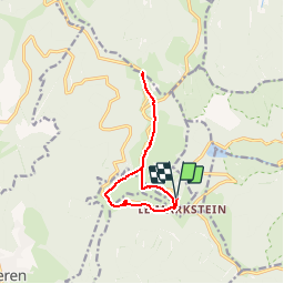

Length
10.1 km

Max alt
1263 m

Uphill gradient
277 m
Km-Effort
13.8 km

Min alt
1159 m

Downhill gradient
277 m
Boucle
Yes
Creation date :
2019-10-11 06:36:09.606
Updated on :
2019-10-11 06:39:26.94
--
Difficulty : Easy

FREE GPS app for hiking
 SityTrail
IGN / Geographical institutes
SityTrail Plus
The world is yours!
About
Trail On foot of 10.1 km to be discovered at Grand Est, Haut-Rhin, Oderen. This trail is proposed by patrickbeyrath.
Positioning
Country:
France
Region :
Grand Est
Department/Province :
Haut-Rhin
Municipality :
Oderen
Location:
Unknown
Start:(Dec)
Start:(UTM)
352857 ; 5309920 (32T) N.
Comments