


2019 a 10 T2

michel1025
User
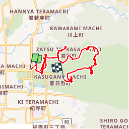

Length
11.1 km

Max alt
331 m

Uphill gradient
388 m
Km-Effort
16.2 km

Min alt
88 m

Downhill gradient
353 m
Boucle
No
Creation date :
2019-10-11 00:25:36.0
Updated on :
2019-10-13 23:04:07.513
4h29
Difficulty : Unknown

FREE GPS app for hiking
 SityTrail
IGN / Geographical institutes
SityTrail World
The world is yours!
About
Trail Walking of 11.1 km to be discovered at Nara Prefecture. This trail is proposed by michel1025.
Positioning
Country:
Japan
Region :
Nara Prefecture
Department/Province :
高市郡 (Takaichi District)
Municipality :
奈良市
Location:
Unknown
Start:(Dec)
Start:(UTM)
576422 ; 3838377 (53S) N.
Comments
Trails nearby