


Gr tour de Mulhouse

domi68440
User
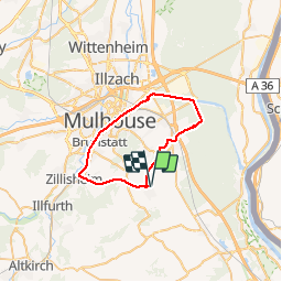

Length
35 km

Max alt
358 m

Uphill gradient
371 m
Km-Effort
40 km

Min alt
227 m

Downhill gradient
369 m
Boucle
Yes
Creation date :
2019-10-14 10:57:09.703
Updated on :
2019-10-14 13:04:41.505
2h06
Difficulty : Medium

FREE GPS app for hiking
 SityTrail
IGN / Geographical institutes
SityTrail Plus
The world is yours!
About
Trail Mountain bike of 35 km to be discovered at Grand Est, Haut-Rhin, Landser. This trail is proposed by domi68440.
Positioning
Country:
France
Region :
Grand Est
Department/Province :
Haut-Rhin
Municipality :
Landser
Location:
Unknown
Start:(Dec)
Start:(UTM)
379284 ; 5283123 (32T) N.
Comments