


Idron : Du Hondais au Chateau d'Idron - RS

mitch1952
User
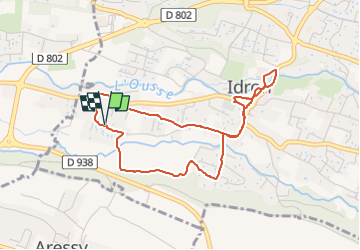

Length
4.5 km

Max alt
232 m

Uphill gradient
32 m
Km-Effort
5 km

Min alt
201 m

Downhill gradient
33 m
Boucle
Yes
Creation date :
2019-10-15 14:13:32.742
Updated on :
2022-06-01 19:15:24.715
2h00
Difficulty : Easy

FREE GPS app for hiking
 SityTrail
IGN / Geographical institutes
SityTrail Plus
The world is yours!
About
Trail Walking of 4.5 km to be discovered at New Aquitaine, Pyrénées-Atlantiques, Idron. This trail is proposed by mitch1952.
Description
Randonnée facile mi sentier mi goudron.
Positioning
Country:
France
Region :
New Aquitaine
Department/Province :
Pyrénées-Atlantiques
Municipality :
Idron
Location:
Unknown
Start:(Dec)
Start:(UTM)
717088 ; 4796351 (30T) N.
Comments