


Tour du Chapeau de Gendarme

andre06130
User
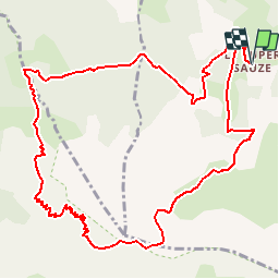

Length
13.9 km

Max alt
2659 m

Uphill gradient
1056 m
Km-Effort
28 km

Min alt
1693 m

Downhill gradient
1057 m
Boucle
Yes
Creation date :
2014-12-10 00:00:00.0
Updated on :
2014-12-10 00:00:00.0
5h40
Difficulty : Difficult

FREE GPS app for hiking
 SityTrail
IGN / Geographical institutes
SityTrail Plus
The world is yours!
About
Trail Walking of 13.9 km to be discovered at Provence-Alpes-Côte d'Azur, Alpes-de-Haute-Provence, Enchastrayes. This trail is proposed by andre06130.
Positioning
Country:
France
Region :
Provence-Alpes-Côte d'Azur
Department/Province :
Alpes-de-Haute-Provence
Municipality :
Enchastrayes
Location:
Unknown
Start:(Dec)
Start:(UTM)
315552 ; 4914182 (32T) N.
Comments