


Thann-Abri du Becherkopf

JCLUTT
User
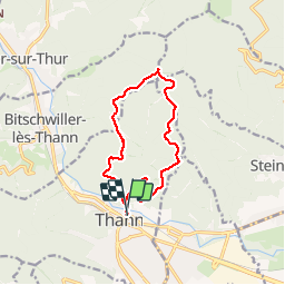

Length
13.2 km

Max alt
876 m

Uphill gradient
603 m
Km-Effort
21 km

Min alt
331 m

Downhill gradient
603 m
Boucle
Yes
Creation date :
2019-10-17 07:00:16.0
Updated on :
2019-10-17 14:10:03.59
4h54
Difficulty : Difficult

FREE GPS app for hiking
 SityTrail
IGN / Geographical institutes
SityTrail Plus
The world is yours!
About
Trail Walking of 13.2 km to be discovered at Grand Est, Haut-Rhin, Thann. This trail is proposed by JCLUTT.
Description
Belle sortie avec de bons dénivelés !
Positioning
Country:
France
Region :
Grand Est
Department/Province :
Haut-Rhin
Municipality :
Thann
Location:
Unknown
Start:(Dec)
Start:(UTM)
358101 ; 5297050 (32T) N.
Comments