


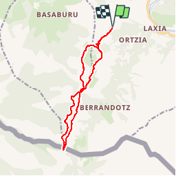
Col du Gorospil depuis Legarre

FERREREMARC
User

Length
14 km

Max alt
692 m

Uphill gradient
568 m
Km-Effort
22 km

Min alt
357 m

Downhill gradient
566 m
Boucle
Yes
Creation date :
2019-10-10 06:53:39.324
Updated on :
2019-10-17 15:50:59.551
6h39
Difficulty : Very easy

FREE GPS app for hiking
 SityTrail
IGN / Geographical institutes
SityTrail Plus
The world is yours!
About
Trail Walking of 14 km to be discovered at New Aquitaine, Pyrénées-Atlantiques, Itxassou. This trail is proposed by FERREREMARC.
Positioning
Country:
France
Region :
New Aquitaine
Department/Province :
Pyrénées-Atlantiques
Municipality :
Itxassou
Location:
Unknown
Start:(Dec)
Start:(UTM)
627956 ; 4796845 (30T) N.
Comments