


mont ventoux 3

soca
User
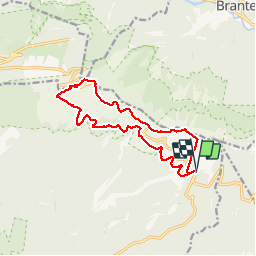

Length
14.6 km

Max alt
1910 m

Uphill gradient
611 m
Km-Effort
23 km

Min alt
1423 m

Downhill gradient
611 m
Boucle
Yes
Creation date :
2019-10-10 08:36:11.09
Updated on :
2019-10-23 05:32:50.239
5h11
Difficulty : Very easy

FREE GPS app for hiking
 SityTrail
IGN / Geographical institutes
SityTrail Plus
The world is yours!
About
Trail Walking of 14.6 km to be discovered at Provence-Alpes-Côte d'Azur, Vaucluse, Bédoin. This trail is proposed by soca.
Positioning
Country:
France
Region :
Provence-Alpes-Côte d'Azur
Department/Province :
Vaucluse
Municipality :
Bédoin
Location:
Unknown
Start:(Dec)
Start:(UTM)
685417 ; 4891382 (31T) N.
Comments