


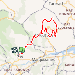
Eus

crognon
User

Length
18.9 km

Max alt
660 m

Uphill gradient
496 m
Km-Effort
25 km

Min alt
378 m

Downhill gradient
496 m
Boucle
Yes
Creation date :
2019-10-25 08:17:39.62
Updated on :
2019-10-25 15:55:40.814
7h37
Difficulty : Difficult

FREE GPS app for hiking
 SityTrail
IGN / Geographical institutes
SityTrail Plus
The world is yours!
About
Trail Walking of 18.9 km to be discovered at Occitania, Pyrénées-Orientales, Eus. This trail is proposed by crognon.
Positioning
Country:
France
Region :
Occitania
Department/Province :
Pyrénées-Orientales
Municipality :
Eus
Location:
Unknown
Start:(Dec)
Start:(UTM)
455381 ; 4721515 (31T) N.
Comments