


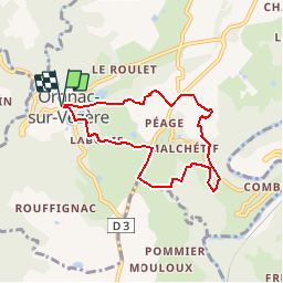
Orgnac - Circuit de Comborn

houbart
User

Length
6.8 km

Max alt
403 m

Uphill gradient
215 m
Km-Effort
9.7 km

Min alt
287 m

Downhill gradient
215 m
Boucle
Yes
Creation date :
2019-10-27 15:34:13.795
Updated on :
2019-10-27 15:43:06.31
1h59
Difficulty : Medium

FREE GPS app for hiking
 SityTrail
IGN / Geographical institutes
SityTrail Plus
The world is yours!
About
Trail Walking of 6.8 km to be discovered at New Aquitaine, Corrèze, Orgnac-sur-Vézère. This trail is proposed by houbart.
Description
Parcours sur les coteaux boisés de l’ancienne vicomté de Comborn.
Passage de la vallée de la Vézère à celle de la Loyre.
Positioning
Country:
France
Region :
New Aquitaine
Department/Province :
Corrèze
Municipality :
Orgnac-sur-Vézère
Location:
Unknown
Start:(Dec)
Start:(UTM)
377804 ; 5020921 (31T) N.
Comments