


Espartignac- Circuit de Surjet

houbart
User
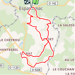

Length
10.1 km

Max alt
464 m

Uphill gradient
234 m
Km-Effort
13.2 km

Min alt
330 m

Downhill gradient
237 m
Boucle
Yes
Creation date :
2019-10-27 15:58:13.245
Updated on :
2019-10-27 16:13:46.752
2h50
Difficulty : Difficult

FREE GPS app for hiking
 SityTrail
IGN / Geographical institutes
SityTrail Plus
The world is yours!
About
Trail Walking of 10.1 km to be discovered at New Aquitaine, Corrèze, Espartignac. This trail is proposed by houbart.
Description
Randonnée entre nature et villages avec point de vue sur les Monédières.
Positioning
Country:
France
Region :
New Aquitaine
Department/Province :
Corrèze
Municipality :
Espartignac
Location:
Unknown
Start:(Dec)
Start:(UTM)
390145 ; 5029986 (31T) N.
Comments