


2019-11-03 WE Aubure Taennchel

holtzv
User GUIDE
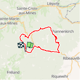

Length
27 km

Max alt
992 m

Uphill gradient
1053 m
Km-Effort
41 km

Min alt
308 m

Downhill gradient
1052 m
Boucle
Yes
Creation date :
2019-11-03 08:28:02.926
Updated on :
2019-11-04 07:46:01.341
7h45
Difficulty : Very easy

FREE GPS app for hiking
 SityTrail
IGN / Geographical institutes
SityTrail Plus
The world is yours!
About
Trail Horseback riding of 27 km to be discovered at Grand Est, Haut-Rhin, Aubure. This trail is proposed by holtzv.
Description
Gite Ferme Oudin Equitation
Journée vers le Taennchel
Photos


Positioning
Country:
France
Region :
Grand Est
Department/Province :
Haut-Rhin
Municipality :
Aubure
Location:
Unknown
Start:(Dec)
Start:(UTM)
367914 ; 5340247 (32U) N.
Comments