


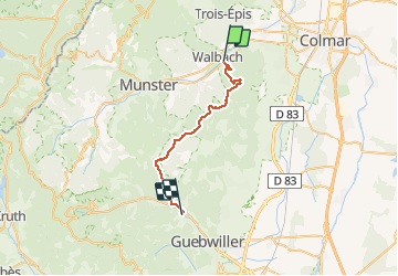
Circuit RdV Wintzenheim - Buhl Opt Foret

Tourisme Equestre Alsace
Promouvoir le Tourisme Equestre en Alsace GUIDE+

Length
27 km

Max alt
909 m

Uphill gradient
887 m
Km-Effort
39 km

Min alt
281 m

Downhill gradient
817 m
Boucle
No
Creation date :
2014-12-10 00:00:00.0
Updated on :
2021-03-14 17:13:40.416
5h05
Difficulty : Difficult

FREE GPS app for hiking
 SityTrail
IGN / Geographical institutes
SityTrail Plus
The world is yours!
About
Trail Horseback riding of 27 km to be discovered at Grand Est, Haut-Rhin, Wintzenheim. This trail is proposed by Tourisme Equestre Alsace.
Photos


Positioning
Country:
France
Region :
Grand Est
Department/Province :
Haut-Rhin
Municipality :
Wintzenheim
Location:
Unknown
Start:(Dec)
Start:(UTM)
368262 ; 5324448 (32U) N.
Comments