Trail Mountain bike Montsalvy - coteaux du goul depuis montsalvy - Photo

coteaux du goul depuis montsalvy

© OpenStreetMap contributors
Length
Length
23 km
Max alt
Max alt
814 m
Uphill gradient
Uphill gradient
752 m
Km-Effort
Km-Effort  
33 km
Min alt
Min alt
274 m
Downhill gradient
Downhill gradient
753 m
Boucle
Boucle
Yes
Creation date :
2014-12-10 00:00:00.0
Updated on :
2014-12-10 00:00:00.0

(2 Reviews)

Mountain bike
Mountain bike
2h08
Difficulty : Medium

Scan this QR Code to open this trail in the SityTrail application

FREE GPS app for hiking

Logo SityTrail SityTrail

IGN / Geographical institutes

Download SityTrail from the App Store Download SityTrail from Google Play

Logo SityTrail SityTrail World

The world is yours!

Download SityTrail from the App Store Download SityTrail from Google Play Download SityTrail on Huawei AppGallery

About

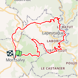
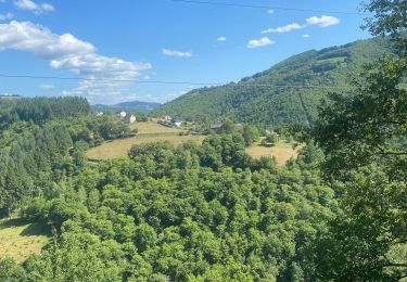
Trail Mountain bike of 23 km to be discovered at Auvergne-Rhône-Alpes, Cantal, Montsalvy. This trail is proposed by kayakiste15.

Description

de montsalvy aux cazottes par chausy puis les grivaldes moledes et pons pour remonter par riols

Elevation profile

Photos

Positioning

Country:
France
Region :
Auvergne-Rhône-Alpes
Department/Province :
Cantal
Municipality :
Montsalvy
Location:
Unknown
Start:(UTM)
460371 ; 4950451 (31T) N.

Comments

Please log in to post a review or rate the element


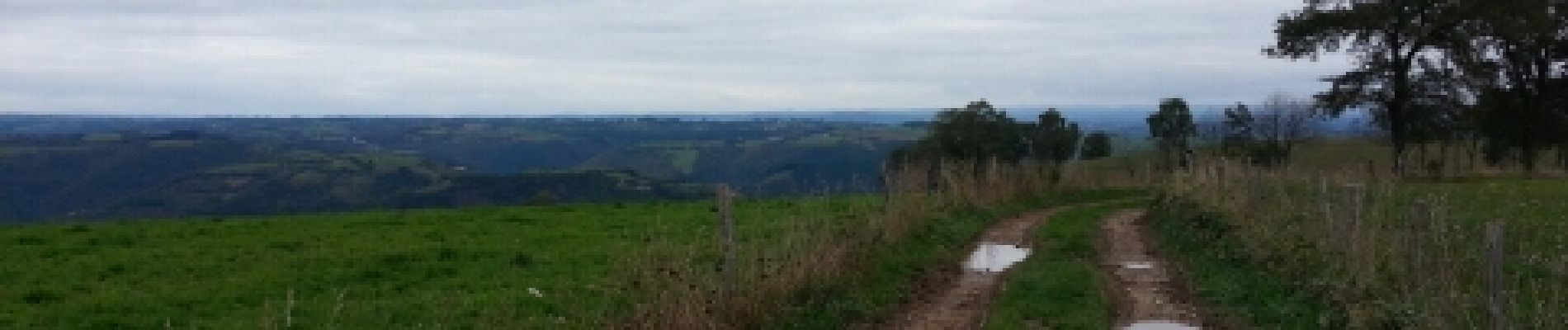
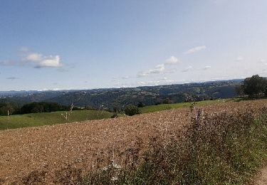
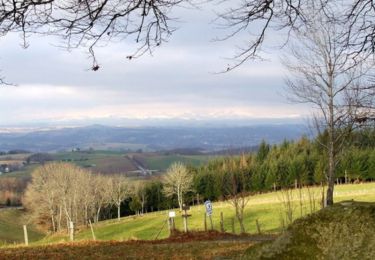
jolie balade avec beaucoup de forêt et quelques points du vue


Trails nearby

Trail Running Montsalvy - montsalvy aubespeyre par le brougnounet, le combal et retour - Photo
Running
kayakiste15

Running

Medium
(1)
Montsalvy, Auvergne-Rhône-Alpes, Cantal, France
10.6 km | 14.4 km-effort
1h 7min
Yes
Trail Walking Montsalvy - montsalvy - Photo
Walking
yves12

Walking

Medium
Montsalvy, Auvergne-Rhône-Alpes, Cantal, France
23 km | 34 km-effort
6h 21min
Yes
Trail Mountain bike Montsalvy - Tour de Montsalvy - Photo
Mountain bike
tracegps

Mountain bike

Medium
Montsalvy, Auvergne-Rhône-Alpes, Cantal, France
15.3 km | 20 km-effort
1h 0min
Yes
Trail Walking Montsalvy - Tour de Montsalvy - Photo
Walking
tracegps

Walking

Medium
Montsalvy, Auvergne-Rhône-Alpes, Cantal, France
15.3 km | 20 km-effort
3h 0min
Yes
Trail Mountain bike Murols - Le batut 1 - Photo
Mountain bike
Patrick Garcia

Mountain bike

Medium
Murols, Occitania, Aveyron, France
19.1 km | 30 km-effort
3h 18min
Yes
Trail Walking Sansac-Veinazès - Rando à Sansac Veinazés - Photo
Walking
tracegps

Walking

Medium
Sansac-Veinazès, Auvergne-Rhône-Alpes, Cantal, France
8 km | 10.9 km-effort
2h 0min
Yes
Trail Mountain bike Montsalvy - montsalvy le mont pons St hypolite riols montsalvy - Photo
Mountain bike
kayakiste15

Mountain bike

Medium
Montsalvy, Auvergne-Rhône-Alpes, Cantal, France
28 km | 42 km-effort
2h 26min
Yes
Trail Walking Entraygues-sur-Truyère - 12_ginolhac_crestes_2024 - Photo
Walking
jab31

Walking

Difficult
Entraygues-sur-Truyère, Occitania, Aveyron, France
18.2 km | 27 km-effort
6h 14min
No
Trail Mountain bike Montsalvy - montsalvy molène St hypolite couesque le village montsalvy - Photo
Mountain bike
kayakiste15

Mountain bike

Difficult
Montsalvy, Auvergne-Rhône-Alpes, Cantal, France
37 km | 55 km-effort
3h 7min
Yes


Close
My subscriptions