


M1 Maucor 9.4kms corrigé

mitch1952
User
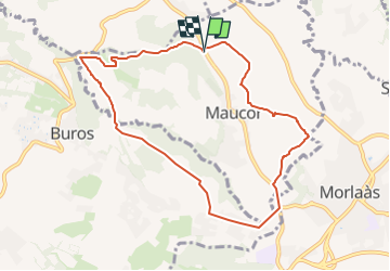

Length
9.3 km

Max alt
339 m

Uphill gradient
184 m
Km-Effort
11.7 km

Min alt
236 m

Downhill gradient
181 m
Boucle
Yes
Creation date :
2019-11-18 19:53:26.678
Updated on :
2022-06-01 19:17:33.263
2h39
Difficulty : Medium

FREE GPS app for hiking
 SityTrail
IGN / Geographical institutes
SityTrail Plus
The world is yours!
About
Trail Walking of 9.3 km to be discovered at New Aquitaine, Pyrénées-Atlantiques, Maucor. This trail is proposed by mitch1952.


Positioning
Country:
France
Region :
New Aquitaine
Department/Province :
Pyrénées-Atlantiques
Municipality :
Maucor
Location:
Unknown
Start:(Dec)
Start:(UTM)
719757 ; 4804535 (30T) N.
Comments