


2019 11 23 Cross plat Herlisheim

staubalex
User
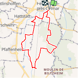

Length
17.5 km

Max alt
208 m

Uphill gradient
78 m
Km-Effort
18.6 km

Min alt
190 m

Downhill gradient
79 m
Boucle
Yes
Creation date :
2019-11-22 16:07:49.443
Updated on :
2019-11-22 16:09:07.361
--
Difficulty : Very easy

FREE GPS app for hiking
 SityTrail
IGN / Geographical institutes
SityTrail Plus
The world is yours!
About
Trail Other activity of 17.5 km to be discovered at Grand Est, Haut-Rhin, Herrlisheim-près-Colmar. This trail is proposed by staubalex.
Positioning
Country:
France
Region :
Grand Est
Department/Province :
Haut-Rhin
Municipality :
Herrlisheim-près-Colmar
Location:
Unknown
Start:(Dec)
Start:(UTM)
375534 ; 5319387 (32U) N.
Comments