


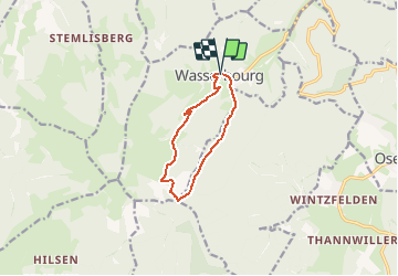
WASSERBOURG-BOENLESGRAB-WASSERBOURG

patrickbeyrath
User

Length
8.3 km

Max alt
893 m

Uphill gradient
382 m
Km-Effort
13.4 km

Min alt
509 m

Downhill gradient
387 m
Boucle
Yes
Creation date :
2018-10-13 05:53:15.097
Updated on :
2018-10-13 05:53:15.103
2h51
Difficulty : Medium

FREE GPS app for hiking
 SityTrail
IGN / Geographical institutes
SityTrail Plus
The world is yours!
About
Trail Walking of 8.3 km to be discovered at Grand Est, Haut-Rhin, Wasserbourg. This trail is proposed by patrickbeyrath.
Description
Départ parking de la mairie WASSERBOURG
Positioning
Country:
France
Region :
Grand Est
Department/Province :
Haut-Rhin
Municipality :
Wasserbourg
Location:
Unknown
Start:(Dec)
Start:(UTM)
362827 ; 5318259 (32U) N.
Comments