


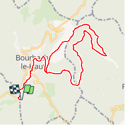
Col du Schirm-Bourbach le Haut - Tombes - Abri du Hochburg et retour par le chemin circulaire

patrickbeyrath
User

Length
11.3 km

Max alt
783 m

Uphill gradient
414 m
Km-Effort
16.9 km

Min alt
533 m

Downhill gradient
415 m
Boucle
Yes
Creation date :
2019-12-06 05:54:40.403
Updated on :
2019-12-06 06:16:36.439
--
Difficulty : Medium

FREE GPS app for hiking
 SityTrail
IGN / Geographical institutes
SityTrail Plus
The world is yours!
About
Trail On foot of 11.3 km to be discovered at Grand Est, Haut-Rhin, Bourbach-le-Haut. This trail is proposed by patrickbeyrath.
Positioning
Country:
France
Region :
Grand Est
Department/Province :
Haut-Rhin
Municipality :
Bourbach-le-Haut
Location:
Unknown
Start:(Dec)
Start:(UTM)
352153 ; 5294545 (32T) N.
Comments