


le corbier col de la chalp

lecmic
User
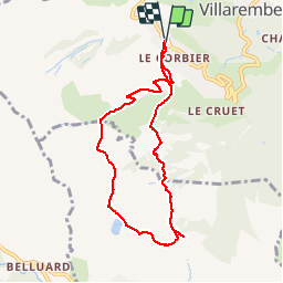

Length
7.8 km

Max alt
1863 m

Uphill gradient
355 m
Km-Effort
12.5 km

Min alt
1568 m

Downhill gradient
357 m
Boucle
Yes
Creation date :
2019-12-07 07:32:17.251
Updated on :
2019-12-07 10:24:58.9
2h51
Difficulty : Very easy

FREE GPS app for hiking
 SityTrail
IGN / Geographical institutes
SityTrail Plus
The world is yours!
About
Trail Walking of 7.8 km to be discovered at Auvergne-Rhône-Alpes, Savoy, Villarembert. This trail is proposed by lecmic.
Description
belle sortie baguettes
Positioning
Country:
France
Region :
Auvergne-Rhône-Alpes
Department/Province :
Savoy
Municipality :
Villarembert
Location:
Unknown
Start:(Dec)
Start:(UTM)
285508 ; 5013478 (32T) N.
Comments