Trail Walking Noisiel - SityTrail - Autour du Val Maubuée - Photo

SityTrail - Autour du Val Maubuée

 vitius
vitius

User

© OpenStreetMap contributors
Length
Length
14.8 km
Max alt
Max alt
111 m
Uphill gradient
Uphill gradient
155 m
Km-Effort
Km-Effort  
16.8 km
Min alt
Min alt
42 m
Downhill gradient
Downhill gradient
156 m
Boucle
Boucle
Yes
Creation date :
2019-12-11 14:08:39.226
Updated on :
2024-02-14 21:34:43.988

(0 Reviews)

Walking
Walking
3h42
Difficulty : Difficult

Scan this QR Code to open this trail in the SityTrail application

FREE GPS app for hiking

Logo SityTrail SityTrail

IGN / Geographical institutes

Download SityTrail from the App Store Download SityTrail from Google Play

Logo SityTrail SityTrail World

The world is yours!

Download SityTrail from the App Store Download SityTrail from Google Play Download SityTrail on Huawei AppGallery

About

Trail Walking of 14.8 km to be discovered at Ile-de-France, Seine-et-Marne, Noisiel. This trail is proposed by vitius.

Description

Randonnée facile permettant de visiter les espaces verts  du val Maubuée

Elevation profile

Points of interest

Point of interest Noisiel - Place Emile Menier - Photo
vitius
Point of interest Champs-sur-Marne - Rond-point - Photo
vitius
CHAMPS-SUR-MARNE 
Point of interest Champs-sur-Marne - Ecole - Photo
vitius
CHAMPS-SUR-MARNE 
Point of interest Champs-sur-Marne - Entrée du Bois de Grâce - Photo
vitius
CHAMPS-SUR-MARNE 
Point of interest Champs-sur-Marne - Rue de Paris - Photo
vitius
CHAMPS-SUR-MARNE 
Point of interest Champs-sur-Marne - Sortie du Parc de Noisiel - Photo
vitius
CHAMPS-SUR-MARNE 
Point of interest Noisiel - Place Emile Menier - Photo
vitius

Positioning

Country:
France
Region :
Ile-de-France
Department/Province :
Seine-et-Marne
Municipality :
Noisiel
Location:
Unknown
Start:(UTM)
472744 ; 5411380 (31U) N.

Trails nearby

Trail Walking Chelles - GRP CV-IDF 06 - Photo
Walking
clalaur

Walking

Medium
(1)
Chelles, Ile-de-France, Seine-et-Marne, France
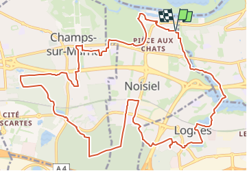
15 km | 16.7 km-effort
3h 47min
No
Trail Walking Saint-Thibault-des-Vignes - Du Parc de Rentilly au Vallon de la Brosse - Photo
Walking

Walking

Medium
(4)
Saint-Thibault-des-Vignes, Ile-de-France, Seine-et-Marne, France
9.8 km | 11.3 km-effort
2h 33min
Yes
Trail On foot Bussy-Saint-Georges - Du Parc de Rentilly au Vallon de la Brosse - Photo
On foot

On foot

Very easy
(1)
Bussy-Saint-Georges, Ile-de-France, Seine-et-Marne, France
5 km | 5.8 km-effort
1h 55min
Yes
Trail Walking Chelles - Bords de Marne de Chelles à Neuilly-sur-Marne 4/5 * 11km - Photo
Walking
GUIDE
Rui Barbosa

Walking

Easy
Chelles, Ile-de-France, Seine-et-Marne, France
11.2 km | 12 km-effort
2h 43min
Yes
Trail Walking Noisiel - Noisiel Grand parcours - Photo
Walking
CC.RIDER

Walking

Easy
(1)
Noisiel, Ile-de-France, Seine-et-Marne, France
21 km | 23 km-effort
4h 50min
Yes
Trail Walking Gouvernes - Vallée de la Brosse - Photo
Walking
PatRando

Walking

Easy
(1)
Gouvernes, Ile-de-France, Seine-et-Marne, France
7.9 km | 9 km-effort
1h 59min
No
Trail Walking Bussy-Saint-Georges - Boucle Rentilly - Noisiel - Etang de la Brosse - Etang de la Loy - Photo
Walking
chessyca

Walking

Very difficult
Bussy-Saint-Georges, Ile-de-France, Seine-et-Marne, France
25 km | 29 km-effort
6h 32min
Yes
Trail Walking Vaires-sur-Marne - Boucle Vaires sur Marne / Noisiel / Chelles - Photo
Walking
chessyca

Walking

Easy
Vaires-sur-Marne, Ile-de-France, Seine-et-Marne, France
21 km | 24 km-effort
4h 33min
Yes
Trail Walking Lognes - lognes -Rentilly par Torcy,  - Photo
Walking
Jean Paul Phommaha

Walking

Difficult
Lognes, Ile-de-France, Seine-et-Marne, France
15.2 km | 17.1 km-effort
3h 37min
Yes


Close
My subscriptions