


SityTrail - Thannbaumann1

JCLUTT
User
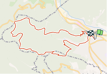

Length
12.5 km

Max alt
735 m

Uphill gradient
483 m
Km-Effort
19 km

Min alt
338 m

Downhill gradient
482 m
Boucle
Yes
Creation date :
2019-12-18 16:16:14.578
Updated on :
2020-07-06 13:19:34.253
3h56
Difficulty : Difficult

FREE GPS app for hiking
 SityTrail
IGN / Geographical institutes
SityTrail Plus
The world is yours!
About
Trail Walking of 12.5 km to be discovered at Grand Est, Haut-Rhin, Thann. This trail is proposed by JCLUTT.


Positioning
Country:
France
Region :
Grand Est
Department/Province :
Haut-Rhin
Municipality :
Thann
Location:
Unknown
Start:(Dec)
Start:(UTM)
358123 ; 5296644 (32T) N.
Comments